How Satellite Cameras Alter Global Business
A corn farmer in Iowa is responsible for 4,000 acres. It is not feasible to walk all rows to see if there is disease. When something seems amiss from the ground, it typically is at that point. That was years ago, when the problem would be found in a whole area of a crop.
Then he started using satellite imagery. Within one growing season, early detection saved a meaningful slice of the harvest. Not because the technology was magic — but because it let him see things that were always there. He just couldn’t reach them before.
That’s the quiet revolution satellite cameras are running on global business right now. Most people picture spy satellites or Google Maps when they hear the term. The reality is much more practical — and much more valuable.
How Does a Satellite Camera Work?
It’s Not Just a Camera
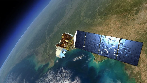
A satellite camera isn’t pointing a phone lens at the Earth and hoping for a clear shot. These are precision optical instruments orbiting hundreds of kilometers above the surface, capturing images with extraordinary consistency and detail.
High-resolution satellite cameras today can resolve objects as small as 30 centimeters across from space. That level of sharpness was classified military technology not long ago. Now businesses buy access to it by the image or by subscription.
What makes modern systems especially powerful is spectral range. Multispectral satellite cameras don’t just photograph what our eyes see. They capture infrared, near-infrared, and other wavelengths invisible to humans. A field that looks green and healthy in regular light might show clear stress signals in infrared — weeks before the crop visibly suffers. That’s an early warning system most farms could never afford to build on the ground.
How powerful are satellite cameras? Powerful enough to count individual shipping containers in a port from orbit. Powerful enough to detect illegal mining activity in a protected rainforest. That kind of reach changes what’s possible for businesses willing to use it.
What the Satellite Cameras Market Looks Like Now
Access Has Opened Up Fast
For decades, satellite imagery was expensive, slow to deliver, and mostly used by governments. That world is gone. The satellite cameras market has grown sharply as launch costs dropped and smaller commercial operators entered the field.
Today, companies can order imagery of almost any location on Earth, sometimes with same-day delivery. Revisit frequencies — how often a satellite passes over the same spot — have shrunk from weeks to hours for some providers. That speed is what transforms satellite cameras from a mapping curiosity into a real business tool.
Industries Quietly Being Rewired
Agriculture: The Invisible Crop Doctor
Farmers globally lose an estimated $800 billion per year to pests and disease. Multispectral satellite cameras have become a genuine frontline defense. They pick up early stress signals, flag irrigation problems, and help predict yields — across areas far too large for any ground crew to cover in time.
The farms seeing the biggest gains aren’t the tech-forward boutique operations. They’re large-scale commodity producers who finally have eyes on every corner of their land.
Mining: Finding the Ore Without Digging First
Traditional mineral exploration is brutally expensive. Teams spend months in remote terrain, often finding nothing. Satellite cameras for surveillance of geological formations let mining companies screen vast areas from a desk. Spectral analysis reveals surface signatures that suggest what might lie below.
Anglo American used this exact approach in Brazil, combining orbital data with ground records to find deposits that would have taken years to locate the old way.
Insurance: The Fraud Killer
Insurance adjusters can’t visit every damaged property after a major storm or wildfire. Satellite imagery fills that gap. Live satellite cameras capture conditions before, during, and after an event — giving insurers visual proof to process claims faster and flag inconsistencies that suggest fraud.
It’s not just efficiency. Its integrity in the claims process, which benefits honest customers most of all.
Logistics: Knowing Before Everyone Else Does
When a major port slows down, or a flood cuts off a supply route, the companies that know first have a real advantage. Logistics operators using satellite data monitor infrastructure and route conditions continuously. That lead time — even a few hours — can mean rerouting a shipment before a competitor even realizes there’s a problem.
The Business Edge Nobody Talks About Enough
Better Information, Better Decisions
Dragonfly satellite cameras and other purpose-built commercial systems give businesses something competitors flying blind simply don’t have: an objective, scalable, persistent view of the world.
Site selection. Supply chain monitoring. Environmental compliance. Competitive intelligence. All of these decisions get sharper when real orbital data is feeding them rather than guesswork or outdated ground surveys.
The technology isn’t futuristic. It’s available now — and the gap between businesses using it and those ignoring it is already measurable.
The View From 500 km Up Is Now a Business Tool
Satellite cameras started as Cold War technology. They became scientific instruments. Now they’re infrastructure for smart business decisions across agriculture, mining, insurance, logistics, and beyond.
The industries that adopted early built durable advantages. The ones still hesitating are making that gap harder to close with every passing season.