Watch Issued for Significant Downpours and Storms in Panama Over the Next Few Days
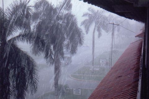
Panama: The Institute of Meteorology and Hydrology of Panama (Impha) reports that unstable weather conditions are expected throughout much of the country for the remainder of the day, with moderate to heavy downpours accompanied by electrical activity. In response, a weather watch has been issued for periods of significant downpours and storms.

Tomorrow: The first downpours will be recorded in maritime areas, moving toward the Caribbean coast, the Azuero Peninsula, and the provinces of Panama and West Panama.
Afternoon: Rainfall will intensify in Panama City, Colón, Coclé, Herrera, Veraguas, and Chiriquí. Isolated but heavy downpours are also forecast in other regions of the country.
Night: Isolated showers with thunderstorms continue in maritime areas, Darien, eastern Panama, the Azuero Peninsula, and the Caribbean coast.
Temperatures: Highs will range between 23°C and 26°C in the Central Mountain Range, and between 28°C and 30°C in the rest of the country.
Winds: Variable winds of up to 20 km/h are expected during the day, increasing to 35 km/h in maritime areas of the Pacific in the afternoon.
Maritime Conditions:
- Caribbean: Waves between 1.0 and 1.6 meters, with periods of 6 to 9 seconds.
- Pacific: Waves between 0.4 and 1.3 meters, with periods of 11 to 15 seconds.
UV-B radiation: Maximum levels will be between 5 and 9, representing a moderate to very high risk level.
⚠️ Impha Warnings:
- Thunderstorms can generate locally strong wind gusts.
- Caution is advised in maritime areas during storm events.
- Saturated soils in Colón, Coclé, Veraguas, the Ngäbe-Buglé region, and the Cordillera Central increase the risk of landslides and rising river and stream levels.